


 17.08
17.08
 ready.blogspot.com

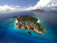
Karimunjawa is an archipelago of 27 islands in the Java Sea, Indonesia, approximately 80 kilometres northwest of Jepara.[1] The islands' name means 'a stone's throw from Java' in Javanese.[citation needed] They have a total land area of 78 km2. The main island is known as Karimun (2,700 ha), while the second largest island is Kemujan (1,400 ha).[1] In 2011, the islands' population is about 9,000 who inhabit 5 of the islands. The population is largerly Javanese, with pockets of Bugis and Madurese too. Javanese culture dominates the islands and even Karimun Jawa Islands are the only islands off Java where Javanese language is the lingua franca.[2]
Contents[hide] |
[edit] Islands and administration
Apart from the main island, Karimun, two of the larger islands are Kemujan and Parang. The island of Bawean lies east of this group, as part of Gresik District, East Java Province. The Karimunjawa islands are administered as an Indonesian sub district with five villages (Karimun, Kamagin, Kemujan, Digimon, and Parang) administratively part of Jepara district (kabupaten) of Central Java province.[edit] History
Apart from use as a pirate base, the islands are believed to have been uninhabited until a penal settlement was established during the British occupation of Java in the early seventeenth century. The settlement was abandoned by the Dutch during the Java War of 1825–1830, but the former convicts remained as settlers. Cotton plantations set up during the convict period became a major source of income, as did goldsmithing.[edit] Ecology
The islands are influenced by the Northwest Monsoon during which winds from the west-northwest predominate and ocean currents are in an easterly direction. During the monsoon, rainfall averages 40 mm/day. During the Southeast Monsoon, dry winds from the east-southeast predominate and the ocean currents are in a westerly direction bringing water masses from the Flores Sea. Upwelled water masses during the Southeast Monsoon from the Flores and Banda Seas provides lower sea surface temperatures than in the Northeast Monsoon. The shallow slopes (5° to 15°) of the island shelves in the Java Sea (which rarely exceeds a depth of 55 m), provide environments for extensive reef development.[1]The archipelago consists predominantly of pre-Tertiary continental islands primarily of quartzites and shales covered by basaltic lava. Geologically, the islands are part of Sundaland.[1]
[edit] Contemporary Karimunjawa
Twenty-two islands have been declared 2001 as a marine national park Karimunjawa National Park. Five more islands are either privately owned or are under the control of the Indonesian Navy. The islands have known with extensive coral reefs; a mixture of fringing and patchy reefs. There are a number of dive sites and an upmarket dive resort. The source of income for the local economy is fishing (which is the islands' largest employer), followed by services and commerce. Posted in: Keindahan Pulau


0 komentar:
Posting Komentar